Wednesday 24 January 2018

Otago Central Railway [60A]: Wingatui to Ranfurly 1

Wingatui to Ranfurly is Part 3 of the article series on the Otago Central Railway. This means I have to have all the knowledge about the line along this route finalised. In addition this part will contain more information about the private sidings of Alexandra. 

Right now I am using the recently obtained chainage book for 0 to 25 miles and another resource to mark in both kilometre and mile pegs from Wingatui to Pukerangi. This completes the degree of milepost marking that can be realistically achieved along the entire route.

I am also drawing maps for the stations from Wingatui to Ranfurly. The only map beyond Ranfurly not completed already is the one of Auripo, which will be quite quick to do. Although Wingatui-Ranfurly seems ambitious in the time I have, I have already done Sutton, Middlemarch, Ngapuna, Rock & Pillar and Hyde, as well as  Taieri Estate, North Taieri, Pukerangi and Hindon. So right now I am needing to do Salisbury, Taioma (both sites), Parera, Mt Allan, Little Mt Allan, Christmas Creek, Deep Stream, Flat Stream, Matarae, Tiroiti, Kokonga, Waipiata and Ranfurly.

However it is more likely only some of these will be completed in the time I have to write this part, and I will have to choose the ones which are for illustrations to be the priority. Ranfurly therefore is likely to be started shortly. It is one of those areas for which there is not currently good quality aerial coverage and therefore diagrams would need to be filled into it. The same goes for many of the locations in the Taieri Gorge. As Salisbury is the last station between Wingatui and Sutton for which reasonably good aerial coverage is available I am about to draw that one. I think that probably Flat Stream and Middlemarch are priorities as well.

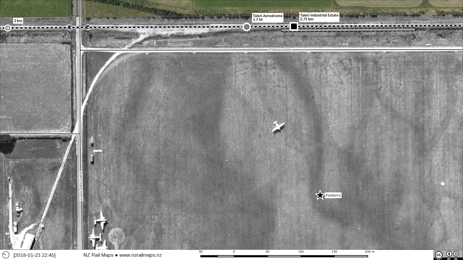
The below are the Taieri Aerodrome and North Taieri maps recently completed.


Taieri Aerodrome 1947


 Aerodrome 1985
Aerodrome 2013

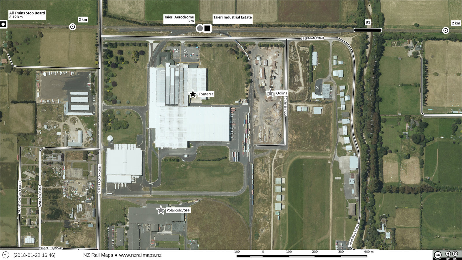
This repeat of the 1947 map shows a passenger platform that existed at the aerodrome site.


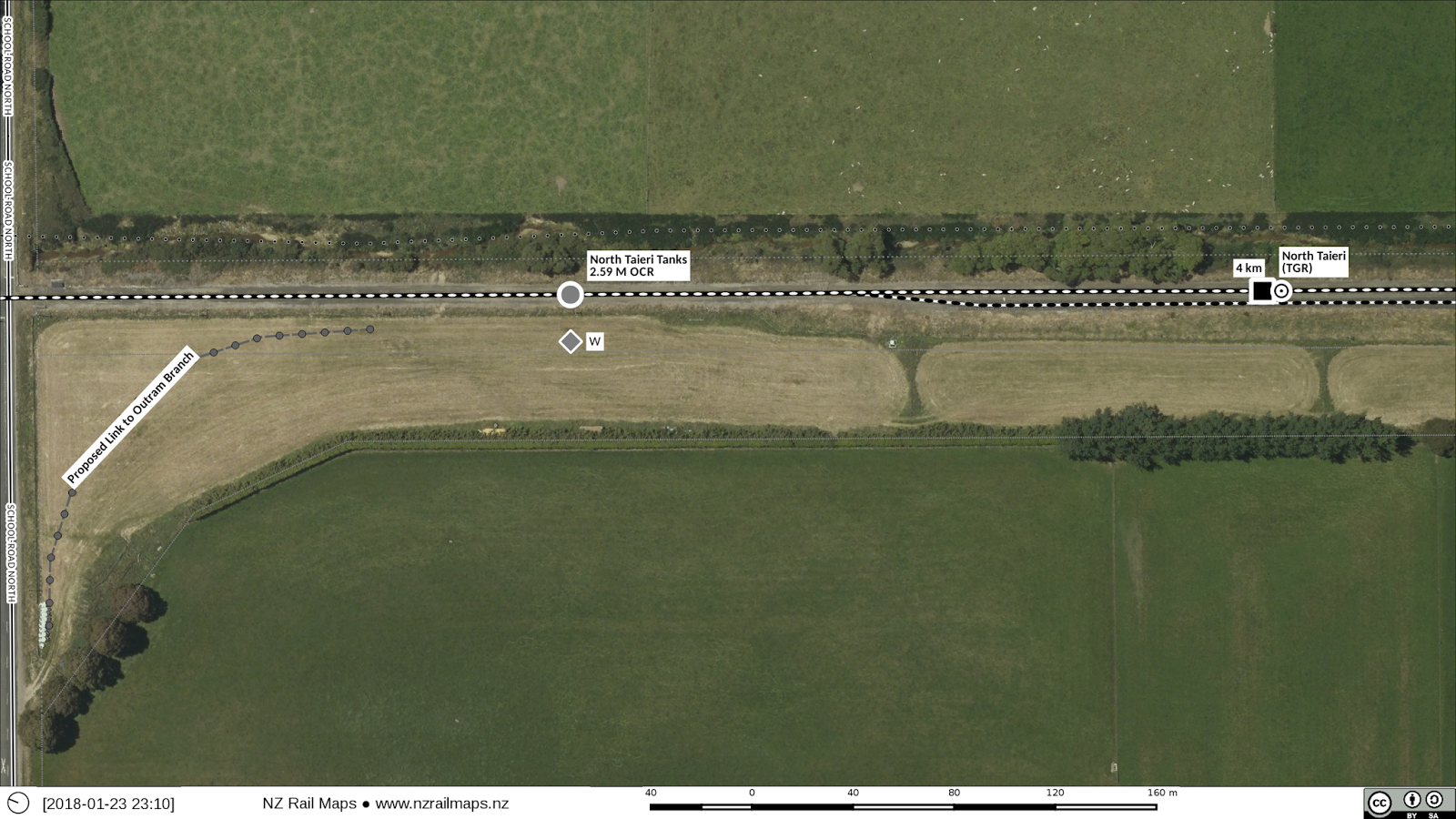
North Taieri (TGR station) and North Taieri Tanks (OCR station). The latter was simply a watering tank.

Saturday 20 January 2018

Otago Central Railway [59A]: Taieri Estate Sidings

As of now I am putting together the aerials needed to show three generations of siding development at Taieri Estate.

Using four images from DCC GIS I am joining these together to make a 1947 image of the aerodrome, which had a siding used to load fuel until the late 1950s. Right now as can be seen from this screen dump, I just have to mask off the borders so that I can get one single continuous image.

For the 1985 era there is one single aerial photo that covers the area, and for current I just use the Linz stuff as is.

Thursday 18 January 2018

Dunedin-Mosgiel Improvement Works 1907-1914

Few people would know today that more than 100 years ago the railway to the south of Dunedin was very different than it is today. The large embankment as it can be seen in many places, particularly between Dunedin and Caversham, simply did not exist in the original construction works as the railway was built. Moreover, by digging around and exploring the area a bit more, it is possible to discover two disused railway tunnels, one buried beneath the streets of suburban Caversham, that have been disused and virtually forgotten for more than a century. How did this come to be the case?
When the railway through South Dunedin was first constructed in the 1870s the builders were faced with issues of geography, namely the hills of Caversham, Burnside, Green Island, Abbotsford and Wingatui. In fact almost the whole of Dunedin is constructed on hills and the entire line between Oamaru and Mosgiel is the hilliest part of the Main South Line by far. From Wingatui to Invercargill on the other hand is almost completely free of such challenges. In hilly country the extra cost of construction can make various compromises inevitable, usually in regard to curvature and gradient. Bridges and tunnels being very expensive works, the early railway builders sought to keep the need for these to a minimum. Lines would be built to the steepest and sharpest alignments possible and improved later when they had proved themselves, thus Dunedin has many improvements made both to the north and the south of the central business district. The compromise that was arrived at for the line to the south of Dunedin in the 1970s entailed the following significant features:
  • From Kensington through Caversham a ruling grade of 1 in 50 to the summit then a similar downhill grade to Green Island at the bottom of the hill.
  • The line then climbed again at grades of up to 1 in 50 to the second summit at Abbotsford. There was then another drop down to Abbots Creek.
  • Another 1 in 50 climb was then faced to get to the top of the Chain Hills before descending again to Wingatui.
  • The Caversham Tunnel of 43 chains was for a significant portion of its length uphill for southbound trains at 1 in 50.
  • The Chain Hills Tunnel of 22 1/2 chains was for a significant portion of its length uphill for southbound trains at 1 in 50.
Due to the development of traffic the improvements became rapidly desirable. The goals for the project included:
  • Duplicating the main line throughout the Dunedin to Mosgiel section. (Ironically, it was singled again in the mid 1980s, and the double track embankment around Caversham was replaced by a new single track embankment so the double track alignment could be reused by a motorway)
  • Improving the gradients to make operation easier
  • Replacing the two single track tunnels with double track bores
  • Eliminating all the level crossings to make operation safer both for the railway and for traffic.
  • Improving the stations along the route.


This map sums up the nature of the improvement works between Dunedin and Mosgiel.

Otago Central Railway [38B]: Hyde maps updated

The main part of Hyde station yard. There was an engine shed from the time the station opened, until about the 1920s. Hyde had both low and high level loading banks. After the ballast pit siding at Hyde Township closed in 1952, ballast continued to be loaded by truck over the HLLB. 
The north end of Hyde yard, including the turntable which dated from the opening of the station. It was relocated to Cromwell in the 1920s. 
 1897 plan of Hyde super
1966 aerial photo of Hyde. Only three of the five houses shown on the 1897 plan remained by this stage, otherwise the yard had changed little from its inception.

Previous article about Hyde

Wednesday 17 January 2018

Project forum

So yesterday I opened a Facebook group for the maps project, and a number of people have joined it. This means I don't need to use the general forums so much, although there will be posts there from time to time to announce progress with different aspects, as well as to keep the membership of those groups informed about the project. Yesterday was pretty busy and today is quiet again, so that is good. Once upon a time back in 2000 I admined a group on Onelist (NZRailways) which was not really an enjoyable experience and I closed it down. With that experience I didn't really want to take on the burden of admining a group again but I have got some people on board to assist and take the workload off me. Today will be back to the hard work of drawing maps again hopefully.

It's very pleasing to see how this thing is really taking off and being blessed after years in the wilderness and a lot of attacks and sniping from some other areas of the NZ rail community, I feel I am able to keep developing it as a hobby provided it doesn't take over my life. So I expect to be continuing with it for the foreseeable future.

Saturday 13 January 2018

Otago Central Railway [58]: Article Part 3

So today I have started working on Part 3 of the article, which will cover the railway from Wingatui to Ranfurly. In order to aid this part and finish some of the detail carried over from other parts, I spent two full days recently at Archives in Dunedin getting as much detail as I could from their files. I believe I would have seen somewhere in the order of 100 different files and copied a whole lot of plans from these files, and a little bit of text.

The biggest lot of stuff I have got from those files is the chainage charts for the rest of the line from Wingatui up so that I can put the detail into the maps. So right now it is going to be full steam ahead on the maps of the Otago Central again, including filling in the missing detail and drawing as many of the yards as I can with the historical aerial photos. However in some cases I will be using yard plans instead of aerial photos and the diagrams from Archives can't be published without permission so they won't get published. It may be that some lower quality aerials will be used for example Auripo where I do have a track layout diagram that I can use in conjunction with the aerial, and the same for the other stations mentioned in an earlier post.

Also because Part 2 is coming out at the end of this month I need to make sure the maps for Part 2 (Ranfurly to Alexandra) are uploaded as a Google Plus collection for public access. Of course all the maps need updating. Some time ago I did aerial montages for various eras for both Clyde and Alexandra but have yet to update the maps for the different eras, so that is an important job to do. So I have done montages for (going backwards) Cromwell, Waenga, Doigs, Clyde, Alexandra, Galloway, Chatto Creek, Omakau, Lauder and Wedderburn. The only ones missing out of the Part 2 section are Auripo and Ida Valley. With the diagrams and a lower quality aerial, I can get started on Auripo right away. It's different for Ida Valley because we don't have anything yet from the time that the station was open (i.e. before 1975) and therefore there isn't anything on the ground that can be traced as far as track and buildings went. So right now Ida Valley will be published as drawn from chainage chart measurements, with a warning label. So to get the Part 2 maps finished, I only need to do one map, which is Auripo. Updating the Clyde and Alexandra maps at the same time will let me ensure that all Part 1 and Part 2 maps are fully up to date, and that will be what is starting to happen straight away.

For Part 3, I need to do montages of Ranfurly, Waipiata, Kokonga, Tiroiti, Hyde, Rock and Pillar, Ngapuna, Middlemarch and Sutton for a start. The coverage more or less peters out from there, although again it may be possible to use lower quality images with the diagrams as a backup. Lower quality imagery is all I have of Ranfurly and Waipiata for the moment. I have track diagrams for almost every station between Sutton and Salisbury, and having the chainage charts now helps to fill in some gaps. Wingatui will also be done and the coverage there is quite good, it is just a matter of picking which era to use. But these Part 3 maps don't need to be published until the end of March, so they don't really need to be finished until then. It will just be for article writing purposes that I will have a look at them over the next month for, and they will finally be finished when Part 3 hits the streets.

Friday 12 January 2018

MSL Dunedin (2J): Updating / Blanket Bay

As you can see I haven't actually put anything out about the station yard. That's because I have got hold of some 1947 aerial photos that will probably be the best ones to see if I can use them for the station yard, if they are sharp enough.

Anyway let's look at something else. Blanket Bay is the next bay south of Sawyers Bay, and the coast-hugging route of the original Dunedin-Port Chalmers Railway went through a tunnel of 101 metres length. As the current tunnel aligned to the causeway is at a length of 313 metres, the single track bore is much shorter.

Every man and his dog has been to Sawyers Bay to try to locate the old tunnel. After all, the Quail Atlas shows the north portal should be right alongside the same end of the current tunnel? Unfortunately, this is one of the many mistakes in the Quail Atlas. As it happens, the south portals are close together (along the railway axis) and this puts the old tunnel in quite a different location relative to the present; about 200 metres further south. So the idea that you are going to find anything in that cutting next to the north portal of the double track tunnel, is regrettably mistaken.

All the below photos use 1947 aerial photography overlaid over current Linz 2013 aerials.

The tunnel basically went under the old road at this point. The highway, which was completely new, cut through the hill where this road crossed over. 


These two views give a fuller picture of the old railway cuttings and how they have been covered over by highway construction. I think it is quite safe to conclude the highway goes almost all the way over the top of the old railway cuttings and tunnel.

The position of the tunnel is corroborated by this NZMS1 map from the early 1940s.

Friday 5 January 2018

MSL Palmerston-Dunedin [9]: Dunback & Makareao Branches

Today's effort has been to update the maps for the Dunback and Makareao Branches.

I am not actually going to post very much here. Go and have a look at the Volume 11 section of the NZ Rail Maps website which I have just set up with the content for these lines and others.


Wednesday 3 January 2018

MSL Dunedin [3]: Historic aerial photos of South Dunedin

A view of the MSL between Kensington and Caversham in 1986. In the lower part of the picture is Hillside Workshops with Carisbrook Stadium directly above it. In the top left the diversion of the MSL off the 1910 double track embankment onto a new single track route to allow for motorway construction is underway. The new single track railway bridge at South Road can be seen under construction next to the 70 year old double track bridge and one of the double tracks is already out of service with much track lifted and the applicable half of the Wilkie Road bridge (and King Edward St bridge not visible in this photo) removed.
This aerial dates from 1979 and shows Caversham before the motorway. The railway coming from the right crosses South Road then enters Caversham station behind the old gas works. It then passes through a section of the suburb that barely exists today - the four overbridges crossing the railway cutting were built in the 1910s when the railway was doubled and realigned between Dunedin and Mosgiel. The construction of the motorway in the mid 1980s simply cut a wide swathe through above the railway cutting and as a result all the bridges were removed except for one converted to a footbridge, changing the streets into cul-de-sacs. The many vacant sections visible above the railway cutting suggest housing clearance was already underway in preparation for the motorway at that time. Towards the left the double track line can be seen passing under South Road and entering the tunnel, while the original single track alignment continues above South Road to reach the original tunnel which still exists today.

MSL Dunedin [2I]

We've started mapping and stopped a couple of times to make further adjustments to the aerials, so not much more has been achieved, but it is just starting to happen now. This is because of the amount of tweaking that can still be done to try to get the images to line up better, and more masking needed as a result of, for example, discovering the siding across Cumberland St into what is these days Spotlight (without a siding) that can be seen lower left. Some of the other detail in this photo includes the Dunedin loco depot, the old rolling stock depot known as "The Gully" that was later taken over by OETT, the old turntable, the former positions of the double track mains (realigned as a single track into the middle of the old yard) and a couple of wagon turntables connecting right angle sidings across Cumberland St as well.

When it came to alignment I exploited the use of the three separate images to get the best possible alignment of the two bridges at either edge (the Water of Leith bridge at the north end and the Andersons Bay Road bridge at the south end) and the station in the middle, whilst also aligning the tracks as much as possible at the joins. This entailed in particular some extra rotation of the north most image. 

The biggest problem is putting dates on everything, for now there is just going to be one composite image with everything mixed in together because in reality I need a lot more different dates of imagery to be able to show reasonably well when things appeared and disappeared. And with the size of this yard, at this time I repeat there are no plans to have multiple generations like I have done with some other stations. But I am waiting for the older stuff going back to the 1940s to come online, as we know Otago is an area that is currently being added and new pictures are coming online every day. I expect it will be possible to find some stuff later than 1978 just for looking at to see what has been happening. The earlier stuff is going to give me a lot more detail like, for example, additional sidings and the old loco depot, of which in the 1978 photos you can just see the foundations, as it was replaced in the early 1970s.

Tuesday 2 January 2018

MSL Dunedin [2H]

So here is finally what it looks like loaded into the map software.
All the detail was actually drawn from the current maps, so this is really a good starting point to appreciate how much has changed in 40 years in Dunedin.

I have decided given the existence of significantly earlier coverage that I won't do maps anywhere else between Port and Mosgiel and on this map Andersons Bay Road is the limit even though the aerials go a little further. Coverage of the entire area will wait until older is available - 1940s, 1950s or maybe 1960s - we shall have to see. But the mapping of this 1978 coverage will begin straight away.

Monday 1 January 2018

MSL Dunedin [2G]

So the masking is now more or less complete having taken somewhat longer than expected, although mostly this is due to other reasons other than the masking itself. I just have to recheck and then I can put out the geojpegs for Qgis. Which is now 2.18 for working on all my maps - no more development masters except to the extent I need to go back to 2.18.

I have looked at what historical aerial imagery exists for Dunedin and it does go back to the 1940s, so we just have to wait until all the historical stuff has been scanned for Otago and it will be possible to do this with preferably 1960s images.